Integrate
our products to ...


We've got you covered
across the full cycle


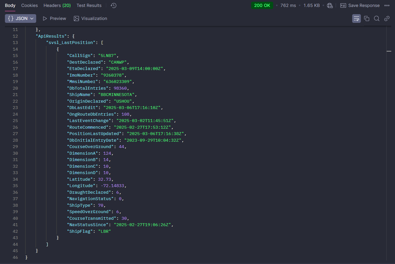
AIS ship positions AIS
- Global Ais Coverage
- Continuosly Updated Vassel Tracking
- Offering By Default Extended Ship Data And Information
- Fleet Monitoring
- 6 Years Of Historical Tracks
- Find Ships By Destination And Eta
- Find Ships Within A Range/Radius From Any Coordinates
Our maritime APIs support every stage of the maritime industry's workflow: from Planning sea voyages and transportation far in advance and Scheduling voyages and shipments down to each detail, to Monitoring real-time vessel-cargo activity, and Reporting any sea voyage’s or shipment’s outturn with ship tracking spanning back six years!
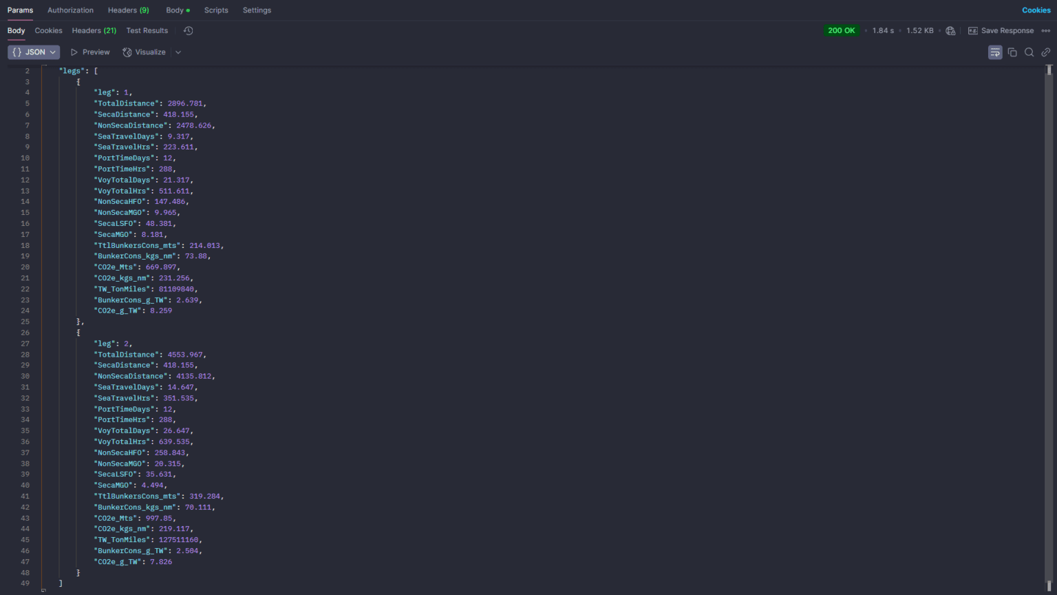
Sea voyage metrics API
- UTILIZES OUR SEA ROUTING API FOR ACCURATE AND ON THE FLY ROUTE CALCULATIONS
- BUNKER CONSUMPTION BREAKDOWN
- TRAVEL TIME BREAKDOWN
- PORT IDLE/WORKING TIME BREAKDOWN
- SECA/NON-SECA MILEAGE AND CONSUMPTION
- DETAILED BUNKERS-EMISSION METRICS
- COSTS THE SAME AS THE SEA ROUTING API
NavAPI’s Voyage Metrics API acts as a lightweight voyage estimation tool. It builds on our Sea Routing API, using dynamically calculated routes to deliver detailed voyage metrics and estimation data. For each voyage leg, it reports fuel consumption (FO/GO, SECA and non-SECA fuels), sea travel time, port idle and working times, and basic emissions data, while also accounting for weather delays. All results are delivered in a single API response. It is priced the same as the standard Sea Routing API and is an excellent tool for quickly and accurately obtaining voyage data.
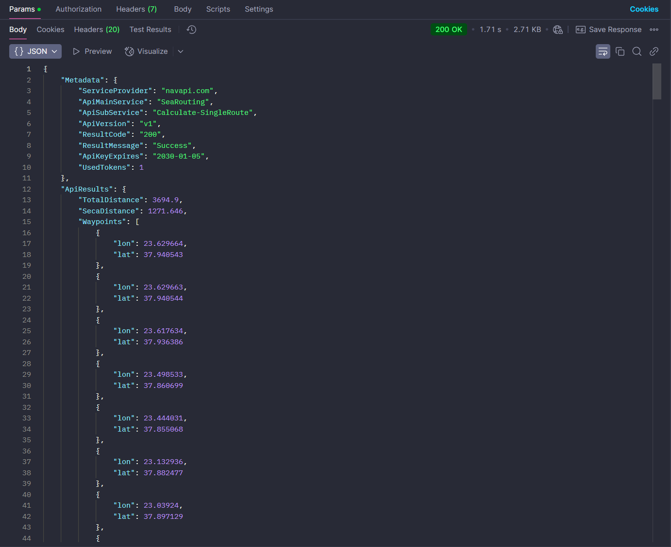
SEA ROUTING API
- GLOBAL SEA AND INLAND ROUTING
- PRECISE SEA ROUTES AND ACCURATE SEA DISTANCES
- FROM/TO ANY PORT OR COORD
- GREAT CIRCLE AND RHUMBLINE NAVIGATION
- SPECIAL AREAS AVOIDANCE/COMPLIANCE
- COMPLETE PORTS DATABASE
- 18 ON/OFF PASSAGES
- ROUTES VIA ALTERNATIVE ROUTE POINTS
- ZONES SEGMENTS
- CROSSED AREAS-CANALS
Our Sea Routing API offers the precision and flexibility needed for reliable nautical distance calculations, voyage estimation, sea travel planning, and scheduling. It is ideal for simulating real-world sea routes, Route-to-go, estimating freight costs, calculating emissions, investigate deviations, monitoring fleet ETAs, managing daily ship operations, matching ships with cargo, and more. With support for both open sea and inland routing, this API is a precise and versatile solution for a wide range of maritime and logistics applications.
GLOBAL WEATHER API
- GLOBAL WEATHER COVERAGE
- MARINE WEATHER DATA
- UPDATED EVERY 6 HRS
- HIGH ACCURACY FORECAST MODELS
- 10 DAYS FORECAST
- POINT AND AREA FORECAST
- ASTRONOMICAL DATA
- 67 WEATHER VARIABLES
- MULTIPLE WEATHER VARIABLES AT A SINGLE RESPONSE
- COMBINE WITH SEA ROUTING TO OBTAIN WEATHER ALONG THE ROUTE
Be aware of weather conditions with accurate forecasting models at any coordinate and across multiple surface and atmospheric levels. Retrieve detailed 10-day predictions, use versatile endpoints offering multiple variables and time steps suitable for meteograms, animated maps, customized visualizations, and tailored insights, and leverage precise astronomical data for effective operational scheduling and informed decision making. This API can also be combined with the Sea Routing API to provide weather along the route information.
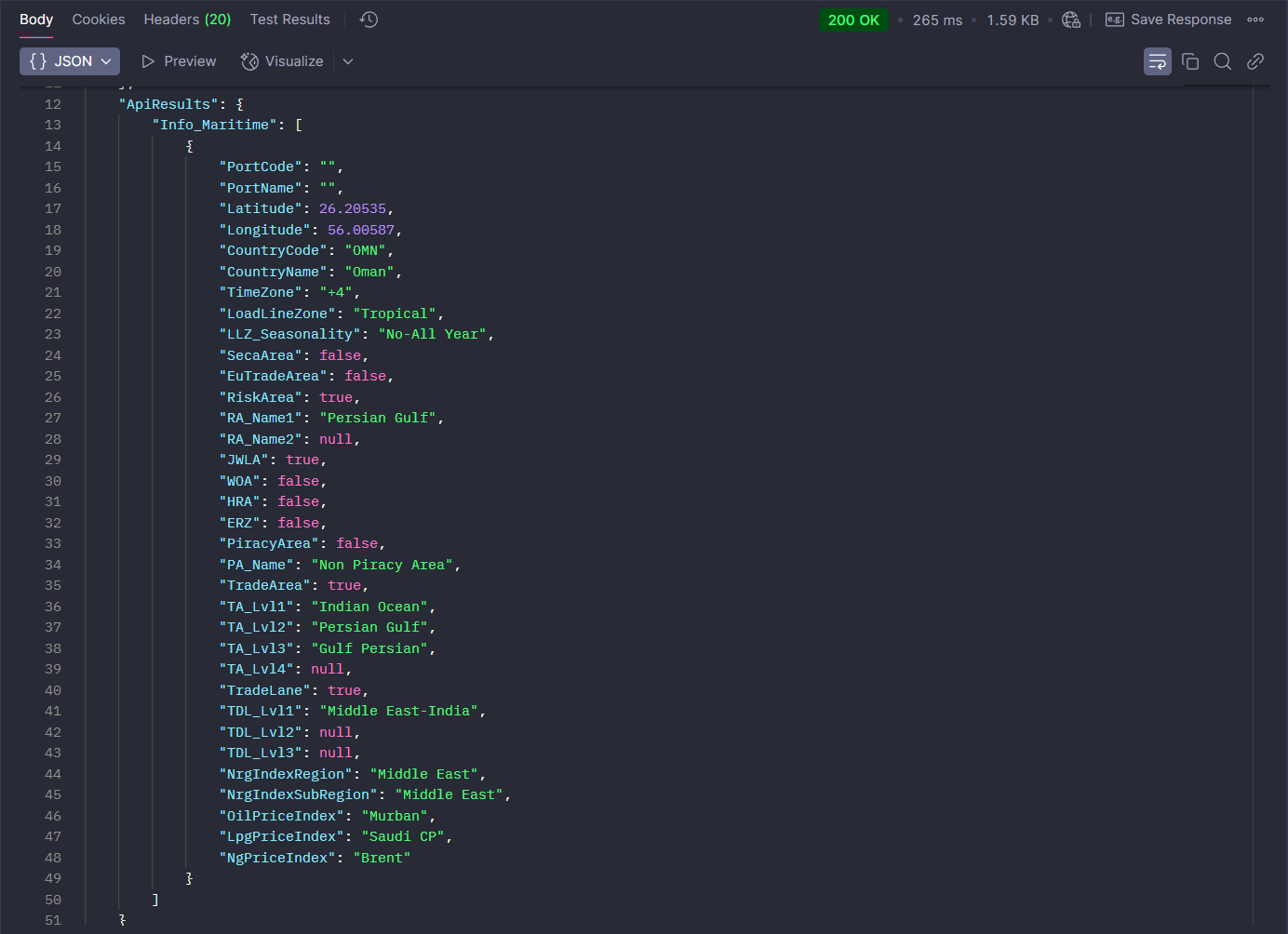
marine GeoCoding API
- WORKS WITH ANY PORT OR COORDINATE IN THE WORLD
- RECEIVE EXTENDED GEOTAGGED MARINE INFORMATION
- SECA/NON AREA-PORT
- EU/NON-EU TRADE AREA
- GLEC TRADE LANES
- RISK AREAS
- JWLA-WAR AREAS
- TIMEZONES
- LOAD LINE ZONES
- ENERGY INDEX AREAS
- SEA AREAS
- PIRACY AREAS
- TRADING AREAS
- TERRITORIAL COUNTRY WATERS
Be aware of weather conditions with accurate forecasting models at any coordinate and across multiple surface and atmospheric levels. Retrieve detailed 10-day predictions, use versatile endpoints offering multiple variables and time steps suitable for meteograms, animated maps, customized visualizations, and tailored insights, and leverage precise astronomical data for effective operational scheduling and informed decision making. This API can also be combined with the Sea Routing API to provide weather along the route information.
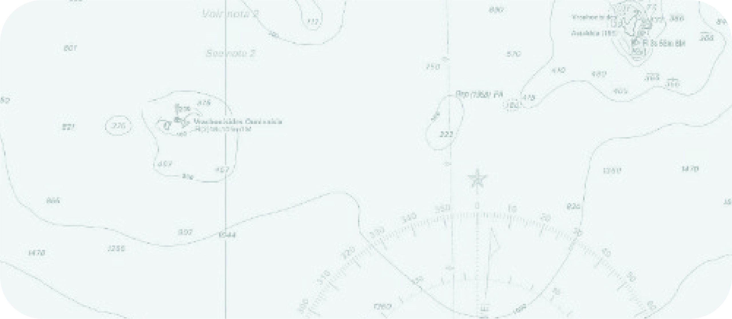
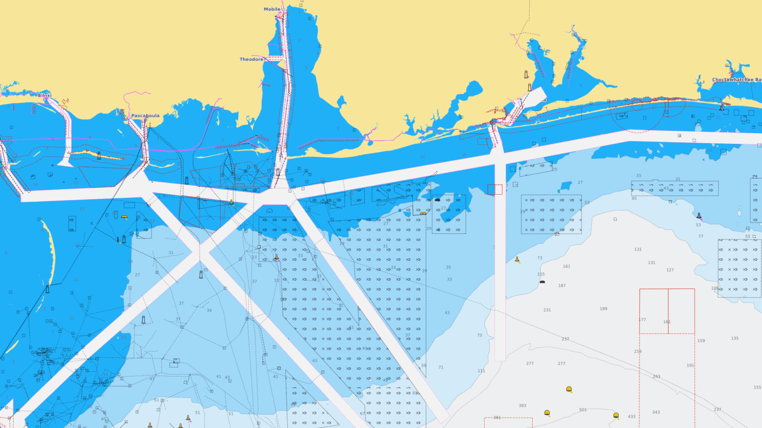
Marine Maps API
- UNLIMITED USAGE
- SUPER EASY INTEGRATION
- WORKS WITH ANY MAP LIBRARY (LEAFLET/ GMAPS/ BING/ OPENLAYERS/ MAPLIBRE ETC.)
- 7 BASEMAPS
- 15 MAP LAYERS
- DEDICATED SEAMARKS LAYER
- REGULAR UPDATES
- WHITE LABELED
- FAST RENDERING WITH CLOUDFLARE CACHING AND INTELLIGENT TRAFFIC GEO STEERING
NavAPI's Marine Maps API offers a variety of basemaps and dedicated maritime layers, including sea ports, SECA areas, MARPOL areas, Load Line Zones, time zones, sea marks, risk and piracy areas, Nordic Plan Areas, Captain of the Port Areas, International Navigating Limits, and more. Easily integrate these regularly updated maps into your applications to visualize essential maritime data, simplify voyage planning, and improve compliance and operational decisions. All included in a single unlimited-use bundle with fixed annual pricing.
Ship Database
- UNLIMITED USAGE
- SUPER EASY INTEGRATION
- WORKS WITH ANY MAP LIBRARY (LEAFLET/ GMAPS/ BING/ OPENLAYERS/ MAPLIBRE ETC.)
- 7 BASEMAPS
- 15 MAP LAYERS
- DEDICATED SEAMARKS LAYER
- REGULAR UPDATES
- WHITE LABELED
- FAST RENDERING WITH CLOUDFLARE CACHING AND INTELLIGENT TRAFFIC GEO STEERING
NavAPI's Marine Maps API offers a variety of basemaps and dedicated maritime layers, including sea ports, SECA areas, MARPOL areas, Load Line Zones, time zones, sea marks, risk and piracy areas, Nordic Plan Areas, Captain of the Port Areas, International Navigating Limits, and more. Easily integrate these regularly updated maps into your applications to visualize essential maritime data, simplify voyage planning, and improve compliance and operational decisions. All included in a single unlimited-use bundle with fixed annual pricing.
Ship Profile
- UNLIMITED USAGE
- SUPER EASY INTEGRATION
- WORKS WITH ANY MAP LIBRARY (LEAFLET/ GMAPS/ BING/ OPENLAYERS/ MAPLIBRE ETC.)
- 7 BASEMAPS
- 15 MAP LAYERS
- DEDICATED SEAMARKS LAYER
- REGULAR UPDATES
- WHITE LABELED
- FAST RENDERING WITH CLOUDFLARE CACHING AND INTELLIGENT TRAFFIC GEO STEERING
NavAPI's Marine Maps API offers a variety of basemaps and dedicated maritime layers, including sea ports, SECA areas, MARPOL areas, Load Line Zones, time zones, sea marks, risk and piracy areas, Nordic Plan Areas, Captain of the Port Areas, International Navigating Limits, and more. Easily integrate these regularly updated maps into your applications to visualize essential maritime data, simplify voyage planning, and improve compliance and operational decisions. All included in a single unlimited-use bundle with fixed annual pricing.
See our APIs in action
Pay for data you can trust
Pay tokens/year
Pay monthly or annually
Upgrade without loosing paid tokens
Add more tokens without upgrading